
In Spending

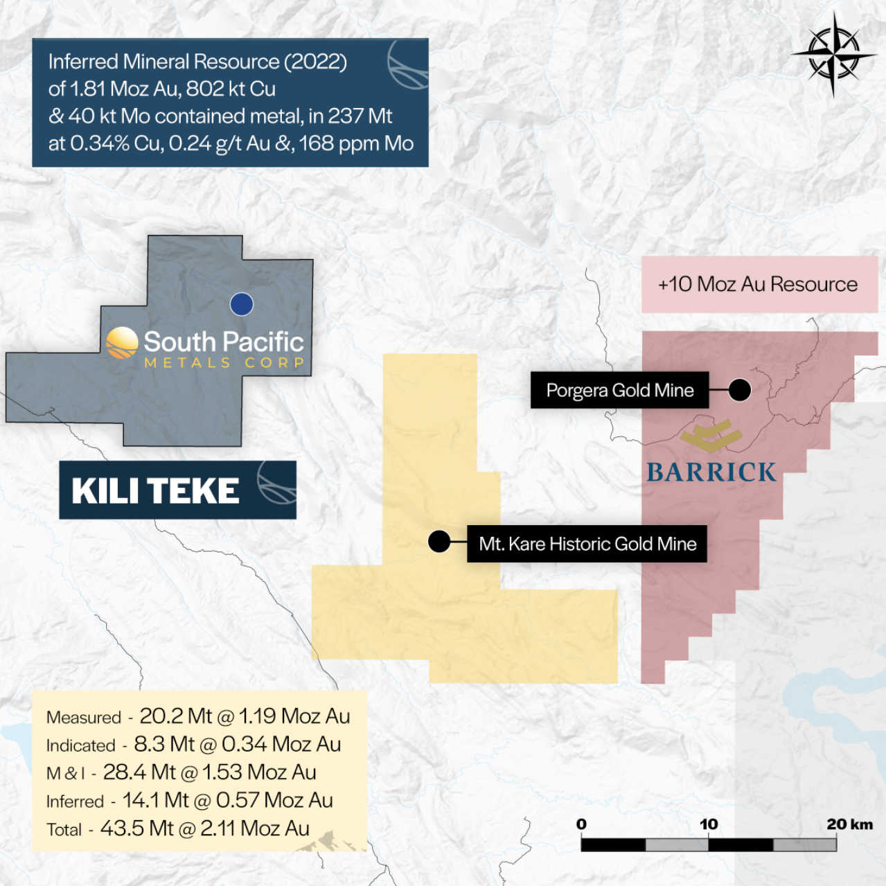
The Kili Teke Project consists of a 253 km2 exploration license (EL 2310), with road access to the tenement and nearby air field. It lies within the Western Highlands of Papua New Guinea within the world-class producing Papuan Fold Belt. It is only 40 km west of Barrick/Zijin’s Porgera Gold Mine, and only 20 km northwest of the Mt. Kare Gold Mine.
The project is 253km² across one Exploration License (EL 2310). Only 6 km from road.
In Spending
The Kili Teke Project consists of a 253 km2 exploration license (EL 2310), with road access to the tenement and nearby air field. It lies within the Western Highlands of Papua New Guinea within the world-class producing Papuan Fold Belt. It is only 40 km west of Barrick/Zijin’s Porgera Gold Mine, and only 20 km northwest of the Mt. Kare Gold Mine.
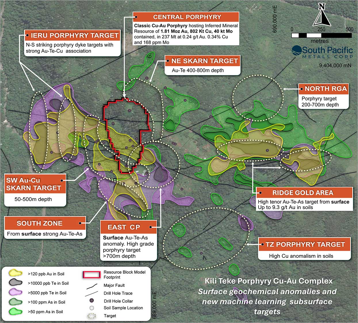
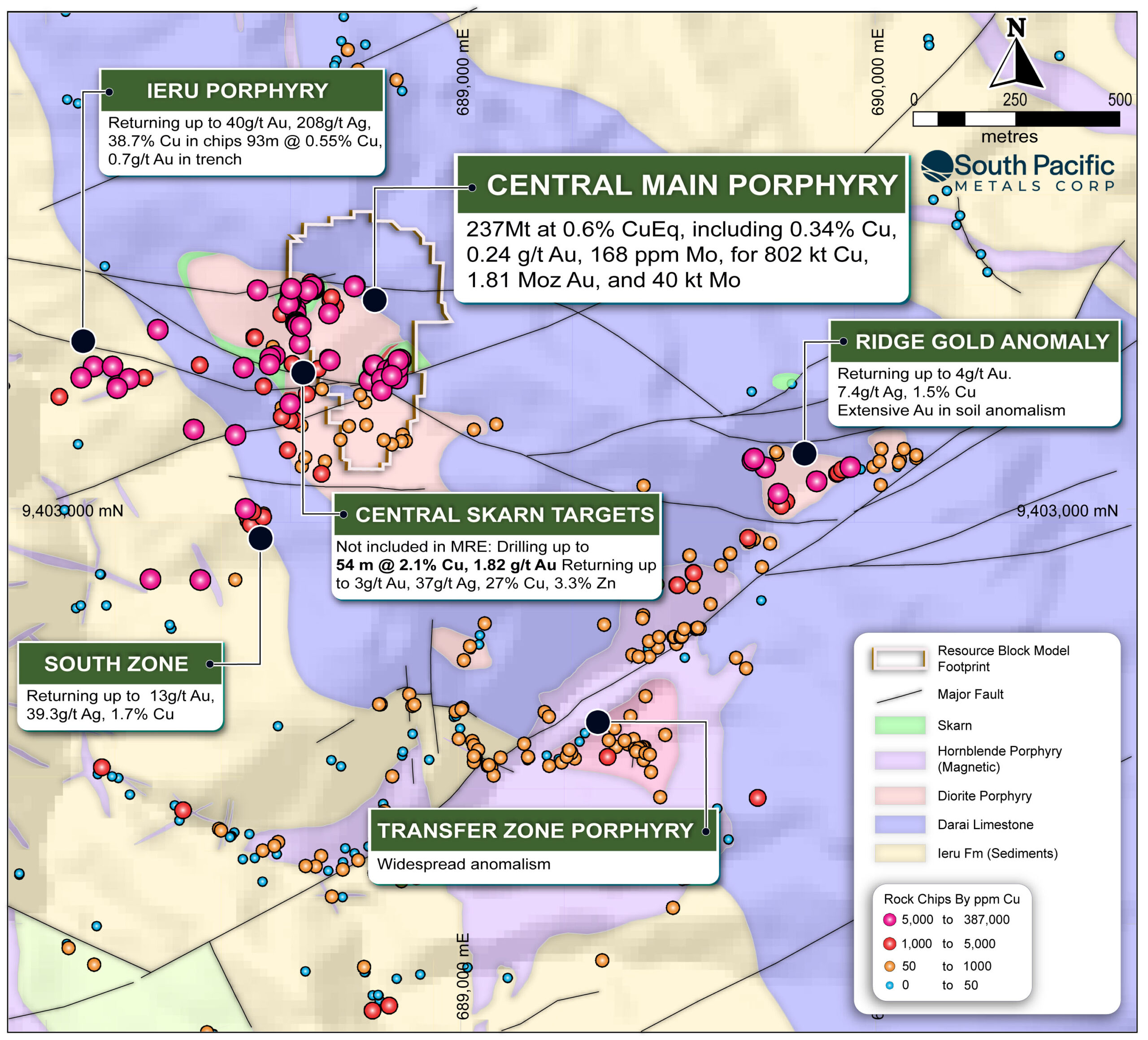
1.81Moz Au, 802Kt Cu & 40Kt Mo Inferred Resource* defined on the Central Porphyry. This is a classic gold-rich copper-molybdenum diorite porphyry with mineralization hosted in a series of stockwork veins and alteration zones. The mineral resource extends over a footprint 500 x 750 metres and from surface to 650 m depth, with mineralization in drilling extending to 1,000 m depth below surface and open.
To date more than 36,000 m drilled at Kili Teke to date, mostly focused on the Central Porphyry
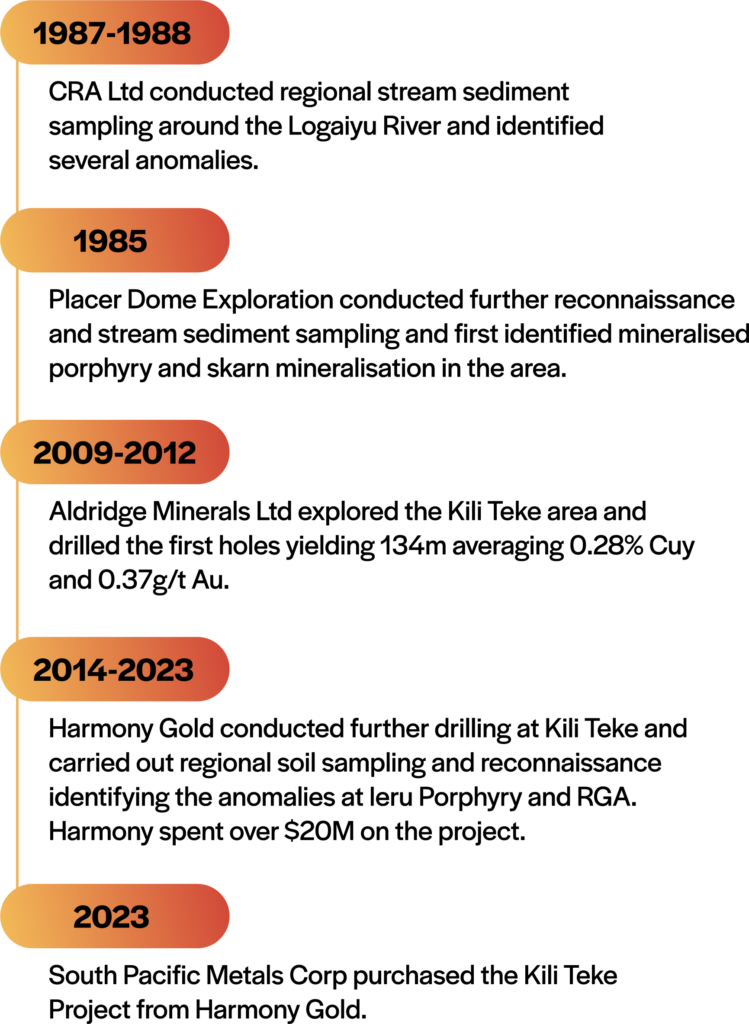
Which hosts the mineral resource. The project was first explored in 1986, when 7.5 g/t Au returned from a river float sample, which was followed up by the identification of altered intrusives and mineralized skarns in 1996. Harmony Gold acquired the project in 2014 and completed extensive exploration and drilling focused in and around the Central Porphyry deposit.
Recent machine learning combined with comprehensive geochemical and geophysical targeting work has revealed multiple avenues for further discovery at Kili Teke. This includes the potential for further high-grade skarn mineralization, as shown in drilling, such as 7.8 m @ 12.98 % Cu, 11.75 g/t Au within 54 m @ 2.1 % Cu, 1.82 g/t Au, 3.87 g/t Ag. Even more exciting is the potential for high-grade Porgera-style alkali gold targets at the Ridge Gold Area. Further, approximately two-thirds of the tenure still has yet to be explored by SPMC.
The project is located in the Papuan Fold Belt—a prolific mineral belt extending for 1500km along the spine of Papua New Guinea and West Papua.
A major transform structure oriented NE-SW (similar to the Porgera-Kare Transform) emplaced porphyry intrusions into metamorphosed and folded shale and limestone sediments.
At least three mineralisation styles are represented including bulk-tonnage targets (Central Porphyry) as well as high grade skarn and Porgera style targets.
Under new management, in early 2024, SPMC set about analysing the large amount of surface geochemistry, geology, drilling and geophysical data. The Company has engaged with consultants to bring cutting edge technologies and analyses to the project.
Kili Teke is more than a modest porphyry. Recent work has revealed the potential for high-grade skarn mineralisation such as 7.8 m @ 12.98 % Cu, 11.75 g/t Au within 54 m @ 2.1 % Cu, 1.82 g/t Au, 3.87 g/t Ag and perhaps even more exciting, the potential for high-grade Porgera style alkali gold targets at RGA.
Greater than 95% of drill budgets spent to date at Kili Teke have been focused on the CP mineral resource estimate. In early 2024, under new management, we took a step back and reviewed the exploration information.
The Company engaged ALS Geoanalytics, a specialist data analytics and consulting company, which uses machine learning & numerical modelling to undertake a comprehensive work program using all available geoscience data to identify new drill targets.
This work has generated new targets. The Company is currently focusing on community agreements and land-access with the intention of recommencing on-ground work. We are prioritising the high-grade skarn and Porgera style high-grade Au targets (alkali style) targets with a view to expand and increase the grade of the existing resource.
Kili Teke lies within west-east striking Papuan Fold Belt—a >20 million year old mountain range formed from the collision and subduction of the Pacific Plate beneath the Indo-Australian Plate. The oldest rocks recorded at Kili Teke include the Cretaceous Ieru Formation comprising carbonaceous shales and sediments, which are overlain by the Miocene Darai Limestone.
Around 5 to 2.5 milllion years ago a NE-SW striking transform fault activated and provided the pathway for porphyry intrusions to be emplaced resulting in considerable hydrothermal activity and multiple-phases of mineralisation.
Analogous transform faults and the same host rocks occur also at the Ok Tedi copper-gold mine to the west of Kili Teke and the Porgera and Mt Kare Gold Mines to the east of Kili Teke.
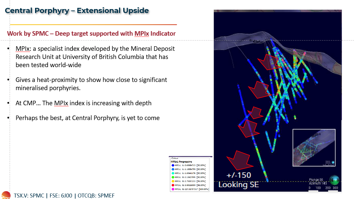
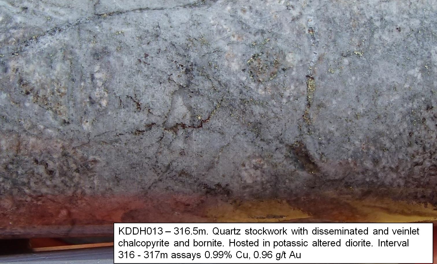
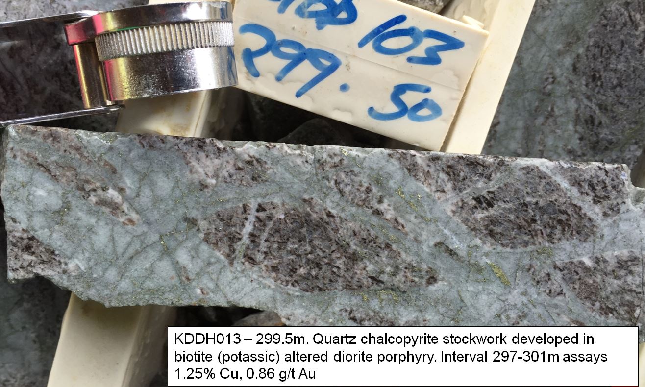
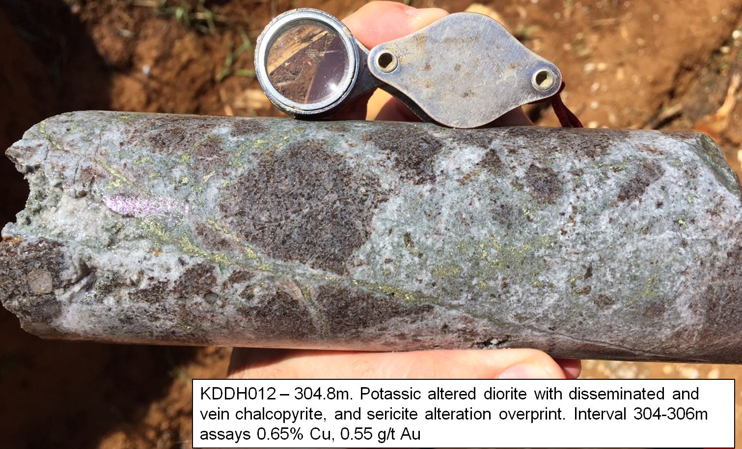
The CP is a classic copper-gold-molybdenum bearing poly-phase diorite porphyry with mineralisation hosted in a series of stockwork veins and alteration zones. The CP mineral system extends over a footprint 500×750 metres and from surface to > 700m deep.
The CP presents as an almost fully preserved porphyry system, with alteration styles very similar to classic porphyry Cu-Au model with a central core of potassic, grading to propylitic, advanced argillic and phyllic styles. There is an increasing Cu:S ratio at depth. Recent 3D modelling presents several targets at depth; where there remains excellent potential for considerably higher grades than those in the near-surface resource.
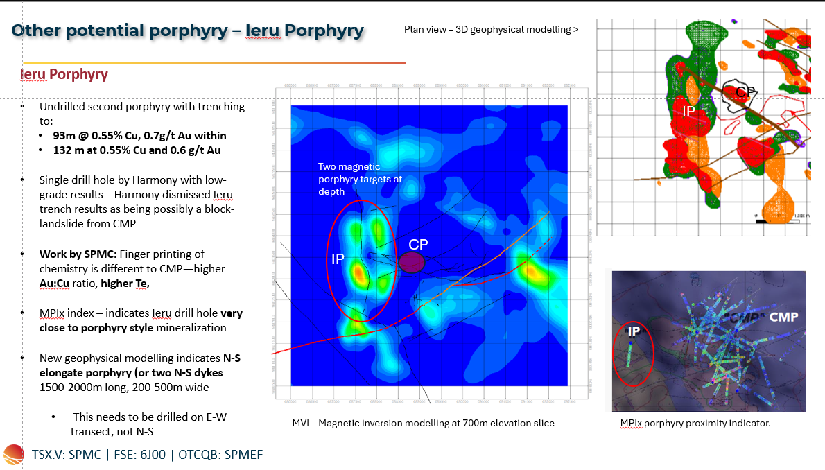
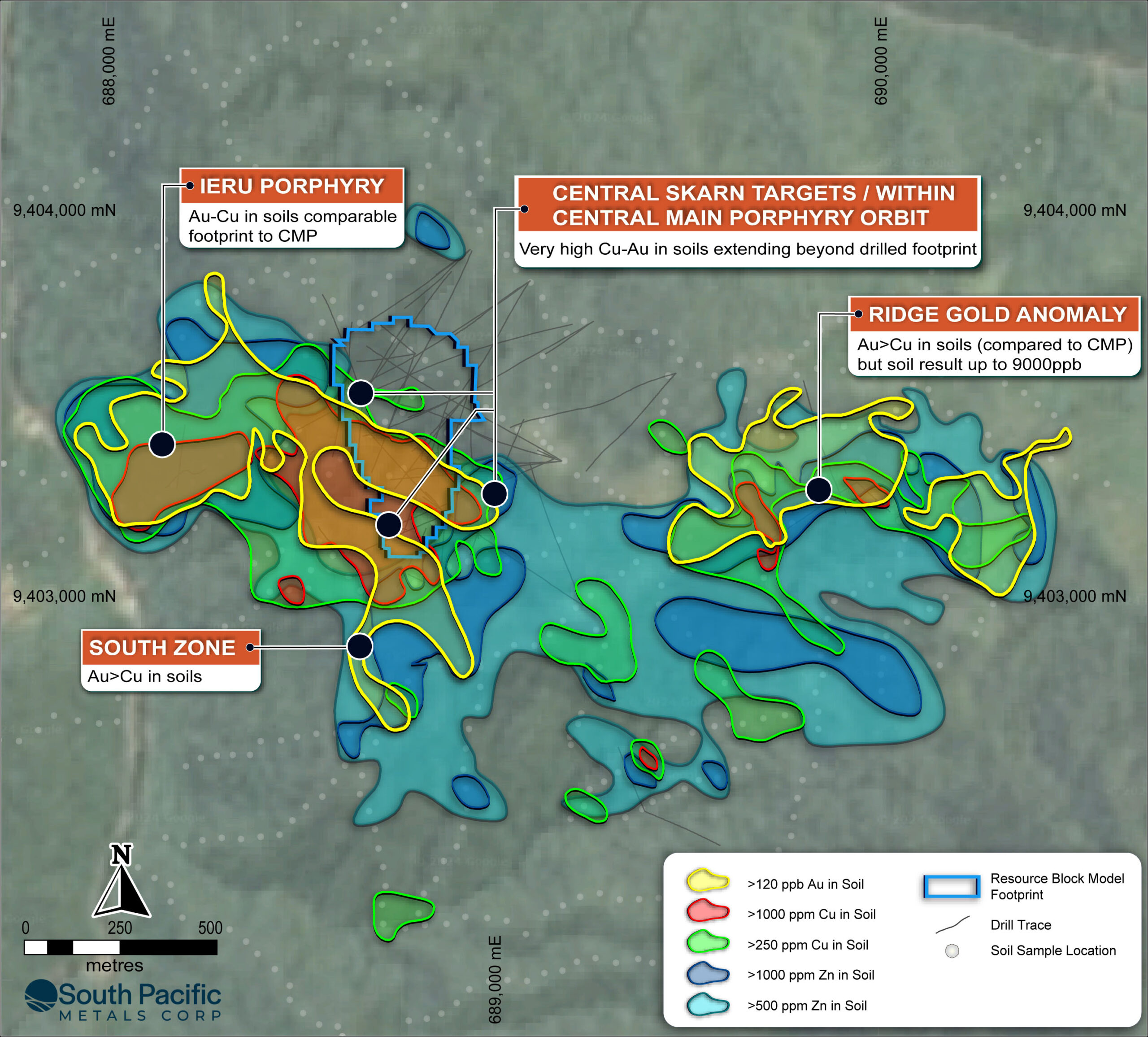
Other porphyry bodies include the Ieru Porphyry that is largely untested with drilling, though surface trench results included 132m averaging 0.5% Cu and 0.6g/t Au.
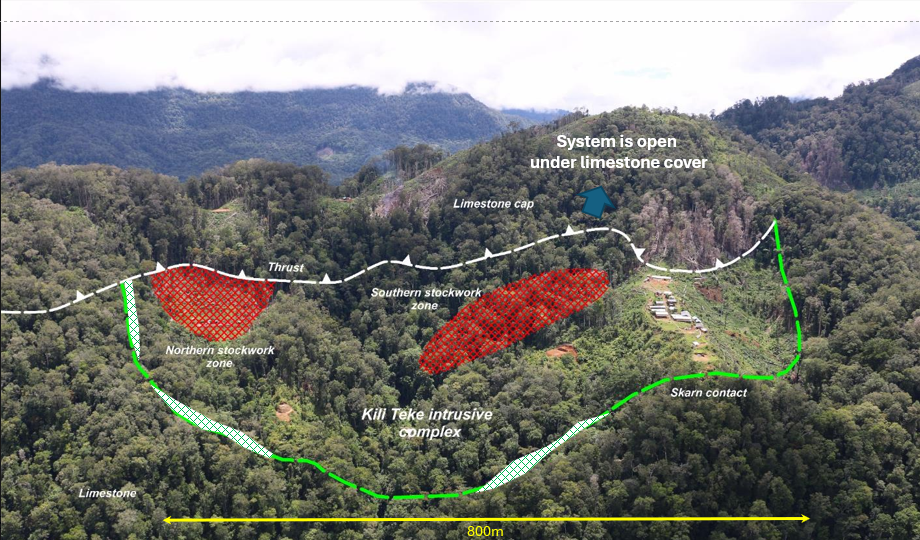
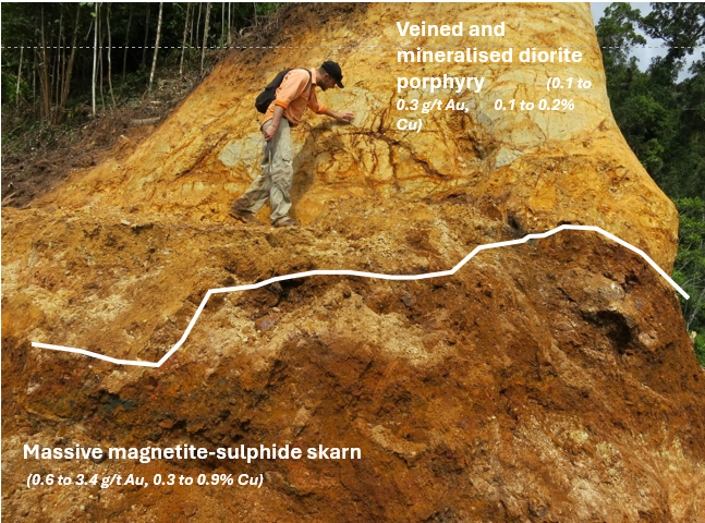
The limestone surrounding the porphyry is heavily altered. Carbonate rich rocks have reacted with mineralising fluids and have deposited massive sulphide and skarn-mineralisation as evidenced in drilling such as 7.8 m @ 12.98 % Cu, 11.75 g/t Au within 54 m @ 2.1 % Cu, 1.82 g/t Au, 3.87 g/t Ag.
Modelling of limestone and intrusions has highlighted several high-grade skarn target areas, especially on the south to south western sides of the CP.
At the Ridge Gold Area (RGA) petrographic (microscope studies) has revealed an increase in potassium feldspar classifying a porphyry as more monzodiorite–an alkali intrusion.
Coupled with a series of generally E-W striking structures, high-grade gold in soil samples up to 9300ppb Au (9.3g/t Au) within a 500 x 900m soil anomaly averaging >120ppb Au, >10000ppb Te & >100ppb As, the RGA presents as a potential Porgera style alkali gold target. Previous drilling at RGA was drilled from north to the south, and are believed to have missed the south-dipping target structures.
Other similar style targets including East CP and South Zone, where high grade Au-Cu-Te mineralisation is noted at surface, and extensive anomalies remain untested with drilling.
Alkali epithermal gold targets represent a particular class of epithermal gold deposit and are noted for the large size (generally > 5Moz Au), and considerable vertical extents (>800m). Porgera in PNG, Cadia/Ridgeway in New South Wales (Aus), Cripple Creek (Colorado, US), and Vatakoula (Fiji) are all classified as alkali systems.