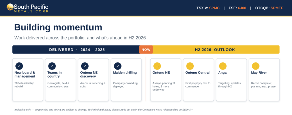
Vancouver, B.C. – June 9, 2022 – Kainantu Resources Ltd. (TSX-V: KRL) (“KRL” or the “Company”), the Asia-Pacific focused gold mining company, is pleased to announce outcomes from the recently completed airborne geophysical survey conducted over both its KRL North and KRL South projects.
The completion of airborne geophysical surveying and analysis over the Kainantu region supports the highly prospective nature of the KRL tenement portfolio for porphyry Cu-Au and epithermal Au deposits (which is on trend with the successful K92 mine).
Highlights
Key highlights of the airborne geophysics programme include the following:
- total area covered of 186 km² (involving over 1,000 line-kilometres) in survey by Expert Geophysics Ltd. (“EGL”);
- advanced processing and modelling; with 3D inversion conductivity models, and magnetic susceptibility and magnetization vector models completed by Computational Geosciences Inc earlier this month – key findings below;
KRL North
- two large magnetic anomalies in highly permeable structural environments identified to the south west and south east, both have been interpreted as possible porphyries;
- the southwest body appears bound by a prominent highly conductive NE trending fault and is associated with a ring feature (in addition to peripheral precious and base metal mineralisation to the north and northwest);
- the southeast body occupies a complex structural zone of prominent intersecting NE and NW faults, some highly conductive and appears associated with a recently identified zone of low temperature hydrothermal alteration and mineralisation in the Young Creek area;
KRL South
- magnetic signatures indicate a possible offshoot from the main batholithic Elandora Porphyry complex occupying the center of the Tirokave ring feature;
- appears to underly the largely phyllic altered area immediately west of the East Avaninofi Prospect and is consistent with skarn mineralisation mapped and sampled;
- additional prospect identified at Mt. Yungateia north of the Tirokave area, a coincident conductivity/magnetic high which includes a strong/extensive conductivity high orientated SE towards Tebeo Ridge; and
- further regional targets of high prospectivity identified at KRL South – further analysis underway.
Matthew Salthouse, CEO of KRL, commented:
“The KRL airborne geophysics survey and subsequent analysis has proven to be a successful venture for the Company, confirming the highly prospective nature of both KRL North and KRL South; supporting ongoing work at the projects. In addition, the survey has also identified other targets and prospects in the region.”
Background
Located along the world renowned Kainantu Transfer Structure, KRL holds two highly prospective projects, KRL North and KRL South, in a district associated with highly successful mining projects.
KRL North
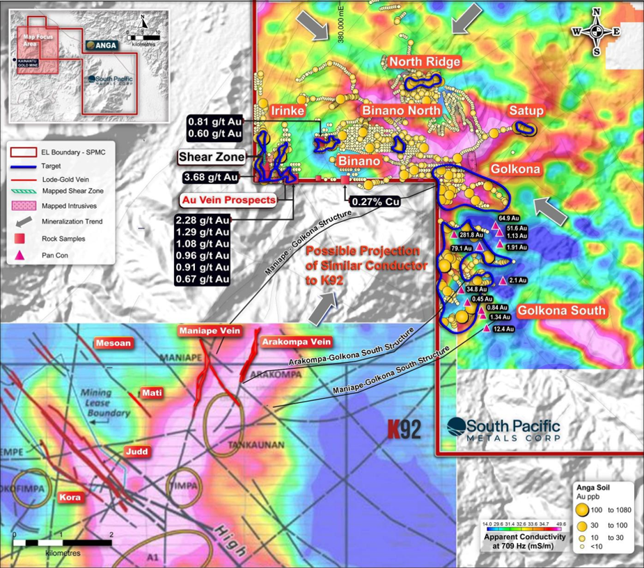
At KRL North, given proximity to the K92 mine, the Company has continued field work and studies to build confidence on the structural similarities and potential trend between the project and the Bilimoia Mineral Field (inclusive of two significant vein systems at Maniape and Arakompa only 2 to 4 km outside of the SE corner of KRL North).
In 2021, a mapping and sampling programme was conducted with the objective of assessing whether such enhanced structural permeability extends into KRL North. Results were extremely encouraging, with several altered and intrusive bodies observed and interpreted as associated with the Elandora Porphyry. A ring feature observed on the southern border of KRL North was found to be underlain by an extensive outcrop of phyllic altered intrusive rocks which was considered to indicate potential porphyry style mineralisation at depth.
Initial analysis from the airborne geophysics program conducted by K92 also appears to demonstrate a NE linear zone of high conductivity trending towards KRL North, likely indicating throughgoing structures possibly associated with contained water and/or sulphide-bearing zones. Further details are contained in KRL’s release of March 10, 2022.
KRL South
At KRL South, the Company’s initial focus has been around the Tirokave area, with three prospects identified for further investigation: East Avaninofi (where a 40 g/t Au sample was collected), Yaoro Ridge and Tebeo Ridge.
The area is of interest has extensive outcrops identified within the Akuna Igneous complex, including scattered dykes and plugs of the Elandora Porphyry and intrusives associated with other successful projects in the region.
Trenching is currently underway at East Avaninofi and Yaoro Ridge, where the company continues to collect samples and undertake further mapping in preparation for potential delineation of drill targets. With the area remaining highly prospective, KRL is also looking more broadly at other regional targets in KRL South.
Airborne Geophysical Survey
As noted in the Company’s release of March 10, 2022, encouraging results and analysis have confirmed the Company’s views on the prospective nature of both KRL North and KRL South, justifying an airborne geophysical survey of the area.
KRL co-operated with other miners in the Kainantu region in Q4 2021/Q1 2022 to share resources to mobilise for airborne geophysical surveys over respective projects, with KRL having flown its survey in January-February 2022.
Airborne survey data was collected by EGL (who operate the Mobile Magneto Tellurics, or Mobile MT system). The area surveyed included all prospective areas of KRL North in addition to key areas of interest in and around the Tirokave area of KRL South (including the East Avaninofi and Yaoro Ridge prospects). Figure 1 below displays the three blocks covered by the survey, totalling 186 km² (involving over 1,000 line-kilometres of survey). The apparent preliminary conductivity analysis from EGL is also presented in Figure 1.
Figure 1: Preliminary apparent conductivity mapping across the Kainantu Region
| KRL North | North Block | EL2558, EL2655 | 533 line-km (97sq.km) |
| KRL South | Tirokave Block | EL2559, EL2650, EL2652 | 263 line-km (43 sq.km) |
| KRL South | Ontenu Block | EL2660 | 259 line-km (46 sq.km) |
Survey lines for all three areas were flown in an E-W direction, at 200m spacing, with tie lines at right angles (N-S), every 2,000m. On completion of the survey in February 2022, EGL completed preliminary data processing and a final survey report was delivered in April 2022.
This data was then delivered to Computational Geosciences Inc. (“CGI”), of Vancouver, who completed advanced processing and modelling; with 3D inversion conductivity models, and magnetic susceptibility and magnetization vector models produced, after data clean-up using a proprietary Power Line Monitor algorithm (which only impacted the eastern part of KRL North). This final work was completed at the start of June and the Company can now report results through to the advanced processing and modelling stage.
Geophysics Results
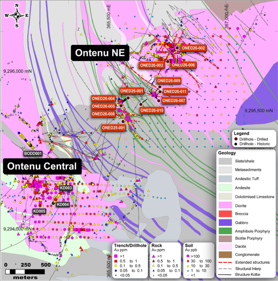
KRL North
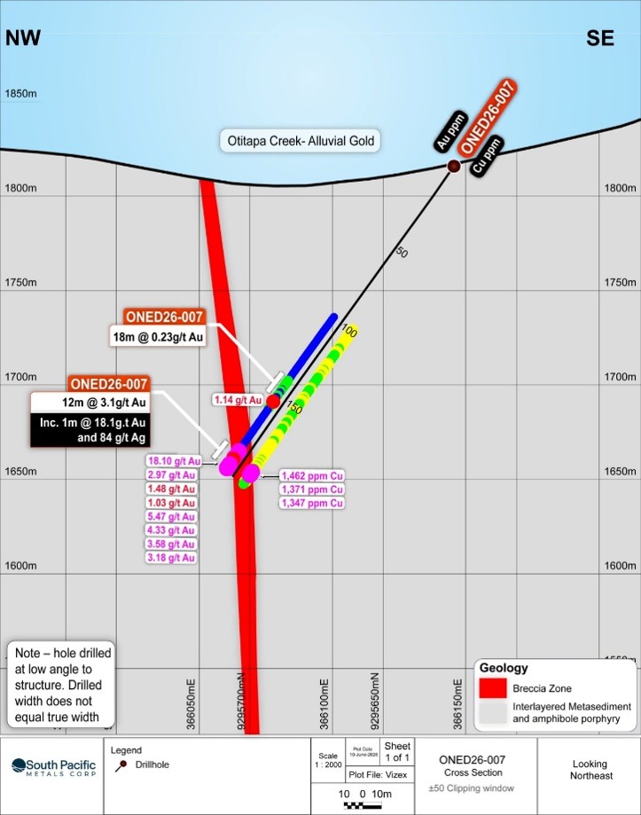
Initial mapping of EGL-derived preliminary apparent conductivity at KRL North had identified a number of high conductivity areas such as the Southern Ring feature, the NE trending Ramu Gorge Fault, the SE corner of EL2655 (known as the Young Creek area) and several other discrete conductivity highs in the south of EL 2655. Figure 2 displays the conductivity pattern over the two exploration licences.
The relative proximity of the Arakompa and Maniape deposits to the apparent conductivity high underlying the southern ring feature area can be noted.
Figure 2: Initial apparent conductivity mapping of KRL North
The final processed conductivity and magnetization models prepared by CGI are set out in Figure 3 below, together with a brief description of the interpretations of each survey block – features of interest are annotated for clarity.
Two large, multi-component, magnetic anomalies interpreted as possible intrusive/extrusive complexes (N1 & N2) – either may be considered a source of mineralising fluids.
The previously identified southern ring feature centred on the triple junction of 3 leases (two held by KRL and one by K92) appears associated with the N1 anomaly and may represent an apophysy of a subjacent igneous body. In this regard, zoned hydrothermal alteration and mineralisation mapped and sampled by KRL to the north and, more recently, northwest of N1 are considered consistent with peripheral mineralisation commonly associated with porphyry style deposits.
A deep-seated, magnetic and conductive, NE-trending linear structure termed the Ramu Gorge Fault (N3) is associated with N1, sub-parallel to the main Kainantu Transfer Fault trend, and several NW-trending magnetic (N4) and conductivity (N5) anomalies are interpreted as permeable structures. Intersections of these NW-trending structures with the Kainantu Transfer trend represent additional exploration targets (areas of enhanced hydrothermal fluid flow).
The recently identified Young Ck zone of low temperature alteration and mineralisation appears associated with the N2 anomaly which is located in a structurally permeable zone of cross-cutting dominantly NE and NW faults & fractures. Prominent NE to NNE trending lineaments shown transecting Akuna Igneous Complex rocks to the immediate southeast of this anomaly prompted KRL to apply for ELA 2755.
Conductive anomalies in the northeast of survey are shallow and interpreted as permeable sediments.
Figure 3: KRL North: A – Magnetic model (elevation -125m),
B – Conductivity model (elevation 175m)
KRL South
At KRL South, the preliminary analysis by EGL at Yaoro Ridge, and north towards Tebeo, is shown to be underlain by a strong and extensive conductivity zone. The strong magnetic high in the center of the Tirokave Ring may indicate several multi-generational magnetic intrusive bodies forming the core of the complex.
The pattern of high conductivity anomalies adds confidence to the reliability of field data and processes in KRL’s predictions.
A strong and extensive conductivity high orientated NW from Tebeo Ridge to the Mt. Yungateia area also appears as a prominent feature, potentially indicating further prospects of hydrothermal alteration and mineralisation in the vicinity of work already underway around Tirokave.
In this regard, the Company has identified Mt. Yungateia as a newly identified prospect which appears underlain by coincident conductivity and magnetic highs.
Figure 4: Preliminary Apparent Conductivity at KRL South – Tirokave Block
In relation to the further advanced analysis by CGI at KRL South, an extensive resistive zone (T1) could represent the batholithic Elandora Porphyry igneous complex largely occupying the center of the Tirokave ring feature, with a small apophysy on its northern margin (T2) situated on the western side of East Avaninofi Prospect, an area displaying extensive phyllic alteration. The latter anomaly is magnetic and may represent a skarn target (small skarn occurrences are commonly noted throughout the prospect areas) and/or an underlying porphyry.
A resistive zone with a conductive core (T3) underlying Mt. Yungateia represents a possible porphyry target. A slightly deeper NW-trending linear conductive zone (T4, parallel to the Kora Vein-trend) is an associated structural target of interest. Hydrothermally-altered porphyritic rocks, with quartz-sulphide veins, along with skarns, have been observed in this area.
Small magnetic features (T5 & T6) are associated with weak, linear N- to NNW-trending conductors.
Figure 5: Tirokave: A – Magnetic model (1800m), B – Conductivity model (2000m),
C – Conductivity model (elevation 1600m)
Next Steps and Conclusions
KRL will continue analysis of data collected from the airborne geophysics programme, which has been extremely useful in supporting the Company’s views as to the highly prospective nature of KRL North and KRL South; while also identifying additional prospects and targets for further investigation at both.
The analysis, combined with ongoing field work, will support the Company’s programme to delineate drilling targets at KRL South; and potentially areas for further intensive efforts at KRL North.
In addition, the Company is currently reviewing the outcomes of the CGI analysis in relation to regional prospectivity and will provide a further update in the near future.
Qualified Person
The scientific and technical information disclosed in this release has been reviewed and approved by Graeme Fleming, B. App. Sc., MAIG, an independent “qualified person” as defined under National Instrument 43-101, Standards of Disclosure for Mineral Projects.
About Kainantu Resources (KRL)
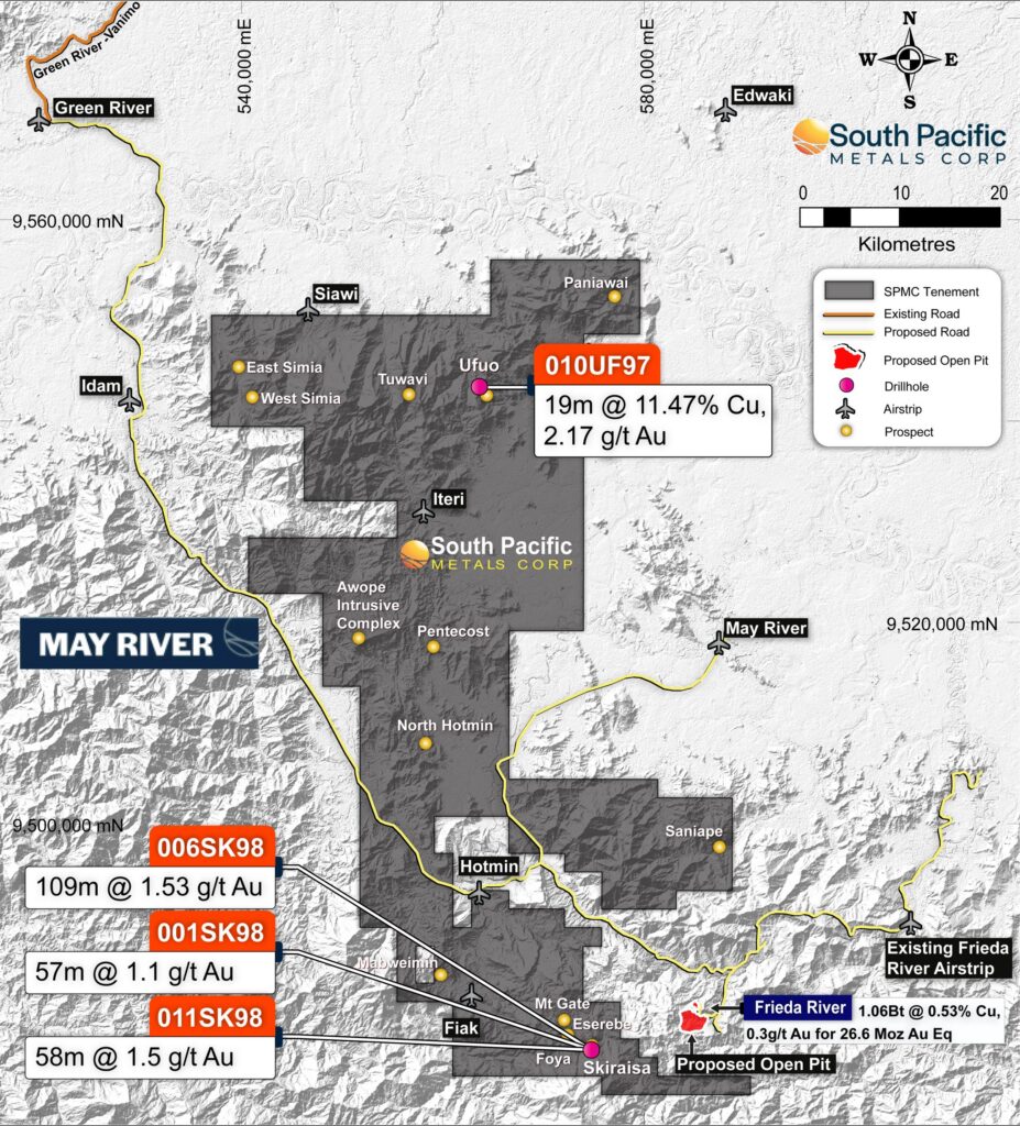
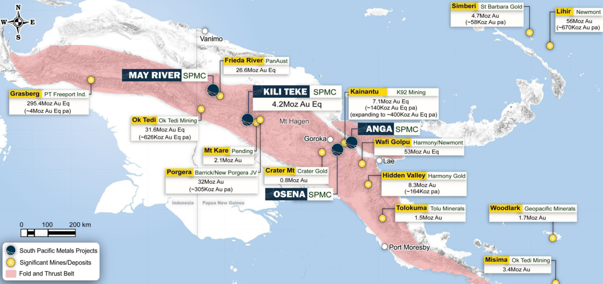
Kainantu Resources ‘KRL’ is an Asia-Pacific focused gold mining company with three highly prospective gold-copper projects, KRL South, KRL North and the May River Project. All projects are located in premier mining regions in PNG. Both KRL North and KRL South show potential to host high-grade epithermal and porphyry mineralisation, as seen elsewhere in the high-grade Kainantu Gold District. The May River project is in close proximity to the world-renowned Frieda River Copper-Gold Project, with historical drilling indicating the potential for significant copper-gold projects. KRL has a highly experienced board and management team with a proven track record of working together in the region; and an established in-country partner. KRL recently executed an agreement to acquire the Kili Teke project in the western highlands of PNG.
Enquiries:
Kainantu Resources
Matthew Salthouse, Chief Executive Officer (Tel: + 65 8318 8125)
Callum Jones, Corporate Development Co-ordinator (Tel: + 61 450 969 697)
Email: info@krl.com.sg
Investor Relations (Gemini Capital):;
Kevin Shum
Tel: +1 212 219 4670 (702)
Email: kevin@jeminicapital.com
For further information please visit https://kainanturesources.com/
Neither the TSX-V nor its Regulation Services Provider (as that term is defined in the policies of the TSX-V) accepts responsibility for the adequacy or accuracy of this release. Disclaimer and Forward-Looking Information Mineralisation hosted on adjacent and/or nearby properties is not necessarily indicative of mineralisation hosted on the Company’s property. The data disclosed in this release relating to drilling results is historical in nature. Neither the Company nor a qualified person has yet verified this data and therefore investors should not place undue reliance on such data, and no representation or warranty, express or implied, is made by the Company, its affiliated companies, or any other person as to its fairness, accuracy, completeness, or correctness. This release contains forward-looking statements, which relate to future events or future performance and reflect management’s current expectations and assumptions. Such forward-looking statements reflect management’s current beliefs and are based on assumptions made by and information currently available to the Company. All statements, other than statements of historical fact, are forward-looking statements or information. Forward-looking statements or information in this news release relate to, among other things: formulation of plans for drill testing; and the success related to any future exploration or development programs. These forward-looking statements and information reflect the Company’s current views with respect to future events and are necessarily based upon a number of assumptions that, while considered reasonable by the Company, are inherently subject to significant operational, business, economic and regulatory uncertainties and contingencies. These assumptions include; success of the Company’s projects; prices for gold remaining as estimated; currency exchange rates remaining as estimated; availability of funds for the Company’s projects; capital, decommissioning and reclamation estimates; prices for energy inputs, labour, materials, supplies and services (including transportation); no labour-related disruptions; no unplanned delays or interruptions in scheduled construction and production; all necessary permits, licenses and regulatory approvals are received in a timely manner; and the ability to comply with environmental, health and safety laws. The foregoing list of assumptions is not exhaustive. The Company cautions the reader that forward-looking statements and information involve known and unknown risks, uncertainties and other factors that may cause actual results and developments to differ materially from those expressed or implied by such forward-looking statements or information contained in this news release and the Company has made assumptions and estimates based on or related to many of these factors. Such factors include, without limitation: fluctuations in gold prices; fluctuations in prices for energy inputs, labour, materials, supplies and services (including transportation); fluctuations in currency markets (such as the Canadian dollar versus the U.S. dollar); operational risks and hazards inherent with the business of mineral exploration; inadequate insurance, or inability to obtain insurance, to cover these risks and hazards; our ability to obtain all necessary permits, licenses and regulatory approvals in a timely manner; changes in laws, regulations and government practices, including environmental, export and import laws and regulations; legal restrictions relating to mineral exploration; increased competition in the mining industry for equipment and qualified personnel; the availability of additional capital; title matters and the additional risks identified in our filings with Canadian securities regulators on SEDAR in Canada (available at www.sedar.com). Although the Company has attempted to identify important factors that could cause actual results to differ materially, there may be other factors that cause results not to be as anticipated, estimated, described, or intended. Investors are cautioned against undue reliance on forward-looking statements or information. These forward-looking statements are made as of the date hereof and, except as required under applicable securities legislation, the Company does not assume any obligation to update or revise them to reflect new events or circumstances.